Showing posts with label Battlefields. Show all posts

Friday, 1 July 2016

On this day - Battle of the Somme starts 1st July 1916

Today is the 100th anniversary of the first day of the Battle of Somme. Although most may not know all the details the battle has entered the subconscious of the British people. The Somme is now a byword for the suffering and horrendous conditions that resulted in trench warfare.

The object shown is a percussion fuse No. 85/44 for a 18pdr shell fired from a British gun [18 pounder] in the Somme area. 
The 'BSC' stamp indicates that this fuse was made by the Bethlehem Steel Company. 
These American built fuses were mainly used with 13 and 18pdr field guns. At the end of the war there were over three thousand 18pdrs in the field which had fired nearly 100 million rounds (99,397,670 to be precise) on the Western front. 

The 85 fuse was based on a 1907 U.S. model, this particular model was introduced in 1916, and made at the Bethlehem Steel Corporation. This firm [Bethlehem Steel] was America's second-largest steel producer and largest shipbuilder. The company provided steel for some of America's most iconic building and structures such as the Hoover Dam, Golden Gate Bridge and the Chrysler Building. 
I've been fortunate to have visited a number of the WWI battlefields, such as Beaumont-Hamel and the Lochnagar Crater. You can (or could) buy these fuses from various shops, museums and cafes collected from the fields (please note that metal detecting in battlefield areas is illegal and dangerous in France and Belgium). 
British 18 pounder gun
Travelling through the French and Belgium sites you will still occasionally see rusty pieces of ordnance stacked by the roadside waiting to be disposed by the army. My dad often tells the story that he saw, a few years ago, two old gents in Belgium kicking round an old shell at the edge of a field. My dad walked away as quickly as possible before the war could claim another victim. 

Although this object may seems a little morbid I use this as a paperweight and it serves to remind me of the futility of war and "man's inhumanity to man". 

Wednesday, 23 September 2015

This Day in History 23rd September

Just to reassure loyal readers that I'm still alive, here are a few images of sites of battles that occurred on this day in history, the Battle of Blore Heath (1459) and the Battle of Powick Bridge (1642). Both battlefields are relatively unchanged (especially Blore Heath). Hopefully I will be able to post more pictures and go into more detail about the areas when I get the opportunity. There are embedded links, the text bits in brackets i.e. [link], if you want more information.

The [Battle of Blore Heath] was the first major engagement between proper armies during the Wars of the Roses which saw an outnumbered Yorkist force defeat a substantial Lancastrian army led during the latter stages of the battle by Lord Dudley [Lord Dudley's banner]. More details can be found on the official site [Bloreheath]. It was also the scene where I very nearly got trampled flat by cattle (probably turncoat Lancastrians as they were on that side of the stream and they may recognised our Dudley accents, which curiously reflected what happened during the real battle). 
Blore Heath
The Battle of Powick Bridge is probably not as well known as the later Battle of Worcester but it could be argued that Powick was the place that saw the start and end of the English Civil Wars.


Powick Bridge
Powick Church
Fans of the ECW period should keep an eye out on this blog as I have a number of future posts dealing with that particular era.

Thursday, 22 August 2013

This Day in History - Battle of Bosworth 22nd August 1485

It was this day in history that the Henry Tudor defeated Richard III in the penultimate battle of the Wars of the Roses. With the recent discovery of Richard's body at Greyfriars in Leicester, plus the screening of the BBC television series 'The White Queen', has raised considerable interest in this time period.

Following on from our visit earlier this year (click here) my brother and myself decided to once again to travel the fifty odd miles and spend a couple of nights in Leicester to explore the city at our leisure and to attend the anniversary re-enactment (I usually get some funny looks/reactions whenever I tell people where I go for my holidays).

On the Sunday we visited Bosworth Battlefield Heritage Centre for their 528th anniversary re-enactment. Once there we had the opportunity to attend the unofficial launch of the book "Bosworth 1485 A Battlefield Rediscovered" by Dr. Foard & Prof. Anne Curry. It's a fascinating read, finally revealing the location to the site that had been lost for hundreds of years. Also the authors convincingly argue that far less combatants were involved than is normally mentioned (the authors using different methods; Curry using the financial accounts and Foard using landscape archaeology to reach their conclusions). There are lots more fascinating insights but you'll have to buy the book to find out.
 
As the visitor centre was due to be refurbished Leicestershire County Council with Lottery funding understandably wanted to know exactly where the battle took place. The relevant experts were given three years to find the precise site of the battlefield after numerous locations had been proposed. The main purpose of the book records the results of this search.
 
In the talk, two years and fifty one weeks into the search Foard honestly admitted that he had given up hope of ever finding the site as no real evidence had been found. In what sounds like the plot from a thriller with just one week left he authorised one final use of metal detectors to check a field on the very outer edge of the possible locations. A small lead shot, just 30mm diameter and undoubtedly from a medieval weapon, saved the day. Given extra funding, and just as importantly time, the team went on to find over thirty pieces of various sized shot along with various other pieces of contemporary military providence.
View from Ambion Hill looking toward Fenn Lanes Farm - site of the conclusion of the battle of Bosworth.
 
One of the many reasons people had been looking in the wrong place was mainly due from the misreading of historical maps which is discussed in detail in the book. Even though the site had been noted during numerous occasions, including a skirmish during the English Civil War, the location itself was eventually lost. It turns out all previous thoughts were wrong, historians Hutton, Nichols, Jones, Wright, Burne, Williams all misplaced the site with only Foss (1998) getting near. The site is actually on the old Roman road (on the particular stretch called Fenn Lanes) between Leicester and Mancetter, located west of Dadlington and north-west Stoke Golding.
 
The location of a long gone marshy area that was pivotal to the battle had also proved problematic but a local farmer mentioned to the team that his tractor had previously become bogged down for three days in a certain field. Further testing confirmed this was the site of the medieval marsh. This was where the high status silver boar livery badge was discovered and probably the site where Richard III died in his attempt to charge Henry Tudor to ground. The vicinity is on private land but there are numerous public paths through the area. A visit to the Bosworth Battlefield Heritage Centre is highly recommended to give you a good idea of the background, plus how and why it happened and where. 

All of this has motivated me to get underway with my own long delayed Wars of the Roses period figures (side by side with two other projects). A Dudley Council historian has given my a far clearer idea of how to proceed with painting the (unknown) livery of Lord Dudley and his retinue which should then enable me to finally publish my eight part posting for this fascinating character.

Sunday, 4 August 2013

This Day in History - Battle of Evesham 4th August 1265 (almost)

My attempt at posting remotely was obviously a dismay failure. This post was supposed to be published yesterday but when I tried to check via my mobile it was clear that it didn't work. I couldn't even access my dashboard with my mobile to publish it that way. Anyways, pretend this is Sunday morning and you still don't know who the new Doctor will be. There was a thunderstorm before the battle just like there been throughout the midlands over the last few days.
 
This is the first in a (hopefully) regular series of posts highlighting various events that took place on 'This Day in history' but adding my own personal slant. My brother and myself have visited hundreds, if not thousands, of historical sites, buildings, castles and battlefields etc. across the world over the years (followers of my recent Twitter feeds will probably have better indication of the number of places we visit).

We recently visited Evesham where one of the main forefathers of modern parliamentary democracy, Simon de Montfort, was killed in battle. Clicking on the following links will take you to sites that will give a far better accounts of the battle and the life of de Montfort himself than I ever can:

Simon de Montfort Society

wiki - Battle of Evesham

Battlefields Trust & Battlefields Trust

The battle took place a mile north of the town centre and is now easily accessible thanks to the hard work of the Simon de Montfort Society and kindly allowed by the landowners. If you do visit, please stick to the proper pathway as it passes through and around fields of barley and fruit trees, which is all still private land.
The path isn't marked that well from the east. We parked on the nearby Tesco's carpark and walked past FS Marble & Granite Ltd (if you're using a new fangled Satnav the post code is WR11 4RA). The path starts down the side of  Ivy Cottage which is just behind the factory.

View from South-west looking north-east towards Green Hill. Simon de Montfort charged uphill from the right towards Prince Edward's army on the left of this image.

 
Charging along this ridge de Montfort would have seen, from left to right Roger de Mortimer, Prince Edward and Earl Gilbert de Clare deploying into battle along Green Hill in the background.
Information panel in the area know as Battle Well.
Battle Well looking west, generally thought to have been were Simon de Montfort was cut down and butchered. With the lost of their leader de Montfort's forces were quickly broken then pursued to the east and south. The remains of de Montfort were gathered and buried in the nearby abbey.
 
As per usual I like to crowbar a reference to Dudley in my posts which is quite easy with this one. Roger de Somery, Baron of Dudley was probably present but not actually fighting. He had been captured, along with the king Henry III, earlier in the year at the Battle of Lewis and was released soon afterwards.

One of my many side projects involves painting numerous figures depicting the knights from this period along with those involved in the Anglo-Welsh wars, including of course the knights and soldiers from Dudley and the surrounding areas. The heraldry from this time lends itself very well to colourful and attractive looking figures but more of this at a later date.

Wednesday, 9 May 2012

Queen's Sconce, Newark-on-Trent, Nottinghamshire

The town of Newark is located on the intersection of the Great North Road, the Fosse Way and the lowest crossing of the River Trent and hence controlled the gateway to the north. During the English Civil Wars the town was besieged three times by Parliament forces. The first two sieges were relieved by Royalist armies. It was after the second siege that the Royalist forces decided to greatly strengthen their defensive positions around the town.
Modern reconstructive illustration
One of the resulting structures, the Queen's Sconce (from a Dutch word meaning fort) is one of Europe's best preserved earthwork fortifications. The Royalist stronghold is named after the wife of Charles I, Queen Henrietta. There was also a King's sconce to the north-east of the town.

Located on elevated ground to the south-west of the town the sconce provided cover to the town, River Devon (previously called the River Smite) and the main roads. 

The third siege began in November 1645 with the Parliamentarian forces being led by General Sydenham Poyntz. Richard Franck wrote in the 'Northern Memoirs' (1658),

"such deep graffs, bastions, horns, half-moons, counterscarps, redoubts, pitfalls, and an impregnable line of sod and turf palisade and stockade every fort so furnished with great guns and cannons that this bulky bulwark of Newark represented to the siegers but one entire sconce."
The Siege lasted six months and on 27th April 1646 Lord John Belasyse Governor of the town, surrendered the town under direct orders from the King.
In one of those strange quirks of history the earthwork survived for the same main reason that caused the town to fall - the plague. After the Royalist surrender the Parliamentarian forces withdrew as quickly as possible from the area due to the threat of plague. The locals were ordered to dismantle all the earthworks but understandably failed to do so. Hence the Queen's Sconce remains in such an impressive state today.
A few quick 'interesting' facts:
  • The sconce covers an area of 1.2 hectares,
  • It is 9m (29' 6" ) high and 92m (302') wide,
  • the ditch (at is widest) is 23m (75' 5") wide and 4.5m (14' 9") deep.
  • Made of earth and gravel from the flood plain of the nearby river, strengthened by timber posts and pegs.
  • Garrison was normally 20 soldiers but 150 when under threat.
  • The sconce housed five artillery pieces during the siege two in both the west and south bastions and a single piece in the east bastion.
Although the sconce is easily visible on Google maps, the scale of the sconce still took me by surprise. The earthwork is now the centre piece of a refurbished park, small trees and bushes have been cleared from the ditches and banks. A small metal footbridge directly opposite the original has been installed enabling easy access into the interior of the earthworks.

View from the east bastion looking inwards.
Note the internal earth ramparts.
View from north bastion looking south west
Note the fields beyond the fort. General Poyntz eventually established his field HQ (on the second line of circumvallation) in this area, just behind where the small modern brick building now stands.
View from the west bastion looking north
On the horizon is visible the spire of the parish Church of St Mary Magdalene. The castle (not visible) is located just to the left of the church.
View from the west to south bastion
Note the modern footbridge.
Inside the tourist information centre, located in the grounds of Newark Castle itself, is a very nicely detailed 1/56 scale (28mm) model of the sconce. It reveals just how formidable the fort must have been during the siege.
Queen's Sconce
1/56 scale model
Interior view of sconce
1/56 scale model
Here's one I made earlier.
This is my attempt at making a similar fortication. Made with the Queen's Sconce in mind, I made this way back in 2009/2010 without visiting the actual site itself.

Sunday, 26 September 2010

Bridgnorth, Shropshire

Compiling the previous blog entry for the Baxter house I realised I was trying to put too much information into a singular post about a model building. Therefore here is a separate post relating more to the town of Bridgnorth itself.

Looking at the St. Leonard’s Close today you would find it hard to believe that it had ever witnessed scenes of extreme violence. On the 8th March 1646 during the English Civil War Parliamentarian besiegers broke through the churchyard defenses and a running battle developed. The town commander Colonel Billingsley and twenty five of his men were killed defending this area from the Parliamentary forces. Later during the same siege, when the church was then being used by the Parliamentarians as an ammunition store, a shot from the castle caused an explosion that destroyed most of the building and started a fire that damaged a large area of the upper town. The body and tower of this now redundant church are mainly Victorian although some traces of medieval building still survive.

St. Leonard's church, the Richard Baxter house is just round the corner to the left of this picture. 

Just a short distance away to the south of the St Leonard’s sits, at a jaunty angle, the town’s castle. In 1642, King Charles I described the view from here at Castle Walk as 'the finest in my domain'. Little remains of the castle apart from the famously tilted (15° off the vertical) Norman stone keep. It always makes me smile thinking about the Parliamentarian engineers seeing the keep as the dust settled, after all their efforts to slight it. I imagine they simply scratched their heads, threw down their pickaxes and walked away either cursing or praising their medieval counterparts.
If you look carefully you may notice the iron hooks on the outside of the left hand wall. It is believed these were added during the ECW siege so that mattresses and other padding could be hung off them to soften the blows from artillery shot coming from the direction of the church.

The TV series Time Team excavated the Castle gardens to the left and behind this picture, looking for any remains of the bailey, and found absolutely bugger all.

On a strange and darker note, fairly recently (2005) papers relating to Operation Sealion were discovered in Germany. These indicated that if Hitler and his Nazi henchmen had conquered Britain Bridgnorth was a proposed location for the German headquarters. Factors such as its central location, good road and rail links, nearby airfield and a small local population were considered to have made it an ideal, and relatively safe, administration centre for the midlands. It’s quite a sobering thought to imagine German jackboots goose-stepping up and down the quintessentially English high street.

View from the Railwaymans Arms looking towards the castle grounds. The keep is immediately to the left of the tallest tree in the background.

On a far less sober note, there are numerous decent pubs throughout the town, but one I would recommend is the Railwaymans Arms. Located on the platform of Bridgnorth station, at the north terminus of the Severn Valley Railway line, it’s very atmospheric even if you don’t particularly like steam trains. Depending on what time you visit it can be like walking into a museum or a film set. And of course the beer is excellent. The pub also gives you a good view of both the castle and the siege earthworks, now called Pan Pudding Hill, built by Henry I in 1102 and located just on the other side of the railway tracks. There is a modern footbridge from the castle gardens over the main road which will take you right to the station.

If you don't want to walk that far then the The White Lion Inn on West Castle Street (yep, near the castle) is also worth visiting.

Monday, 14 June 2010

Naseby

This day in history - Battle of Naseby 14th June 1645


Looking north across Broadmoor from the Parliament positions (location of battlefield monument).

Wednesday, 12 May 2010

Powick Bridge, Worcester

In one of those strange quirks of history Powick Bridge, located just south of Worcester city centre, saw the first and last real military actions of the English Civil War. A similar event took place in the small Belgium village of Casteau where the 4th Dragoon Guards fired the first and last shots of the Great War for the British Army.

The first engagement, the battle of Powick Bridge in September 1642, was more of a cavalry skirmish. Prince Rupert troops chanced until the Parliament camp in the fields around this part of the river Teme and successfully drove off their cavalry. This enhanced the reputation of the Royalist cavalry of being nearly invincible which they enjoyed until the Cromwell’s Ironsides eventually turned up.

Almost exactly nine years later, in 1651, at the Battle of Worcester the bridge was heavy defended by Highland Scottish troops. These were later outflanked when Parliament forces used fords and a pontoon bridge to gain access to the north of the river.

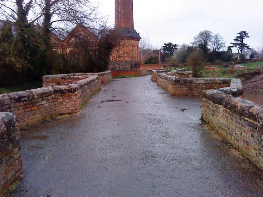
It was during this later period that the two arches closest the further bank (in the image below) were destroyed. At the time of the battle the river could still be crossed using planks linking up over the remains of the abutments. The arches were later rebuilt but in the different style and are now obvious to spot.

Powick Bridge looking north towards Worcester. The large brick building in the background is a former mill that later became the world’s first combined steam/hydro electric power station during the Victorian period.
View on the bridge looking north showing the just how narrow the structure is.


Same spot as above looking back towards Powick village and the 'road' to Great Malvern to the south. This gives a good impression of the type of hedgerows that were so hard fought over during the later battle of Worcester.


As the radical preacher Hugh Peters poignantly said, "When your wives and children shall ask where you have been, and what news, say you have been at Worcester, where England's sorrows began, and where they happily ended."

It is definitely worth the slight detour out of Worcester (previous visit detailed here) to visit Powick, the location of one of the true turning points in British (and it could be argued, world) history.

Monday, 28 September 2009

Newcastle's Whitecoats & Marston Moor

After a recent visit 'up north' we managed to visit the site of the battle of Marston Moor, just seven miles from York. Contrary to what you may think modern farming and drainage has changed the site although fortunately little or no building work has taken place there so it is easy to imagine the course of the battle. Looking into the events of the battle in more detail the story of Newcastle's Whitecoats famous last stand always grabs your attention. This is one of the reasons why I choose to depict one of Warlord Games plastic regiments as the Whitecoats.

The colour scheme as mainly based on Graham Turner's illustration in the Osprey Campaign 119 book. I may have to tame the painting slightly as the shading/highlighting now seems a bit excessive and random.

Newcastle's Whitecoats - First of many, Pikemen.


Musketeers.


To put playing with toy soldiers into some context, here are a few photographs taken from our visit to the battlefield.

Battlefield Monument, raised by the Cromwell Association in 1936, looking towards the Royalist left flank.

Information board detailing the initial battlefield formations.Note the location of the monument.


View looking roughly north-east just in front of the monument. In the middle distance but on the other side of the hedge is Fox Covert. This is one of the possible locations of the famous last stand by the Whitecoats. Ironically Marston Moor is one of the few battles where too much information is available. A number of accounts vary over details.

All these photographs were taken late evening early August. The battle (1644) started around 7pm 2nd July.

Local Royalist Thomas Leveson (Governor of Dudley Castle) also fought for Prince Rupert. Leveson's horse numbered about 200 men.

I will naturally post more pictures, as and when, along with more detailed information on the regiment in due course.

More detailed information is available from the following site:

Monday, 20 April 2009

Bosworth field

View south-east towards Richard's standard, Bosworth (possibly)


After visiting the Hinckley model show where I bought a few bargain second hand books and meet up with the Pensnett model club. As it was a beautiful day my brother and myself decided to travel to nearby Bosworth battlefield.

The new refurbished visitor centre is located on the traditional site of the battle but as the centre honestly admits, there are at least two other possible sites, although all of these alternative locations are all with a few miles of each other.

One of the several highlights include four life size figures in the main display that depict Richard III, Henry Tudor, a man at arms and an ordinary foot soldier.

A clever display, as you enter the main hall, allows you the handle various swords and pole arms while remaining securely fixed to the wall. Good job really, seeing how clumsy I can be. I even managed to walk into a tree later in the day.

My personal favourite display was on the opposite wall. Here it’s dressing up time again. Various authentic helmets, sallets, bevors, padded jackets and a breastplate are available to handle and wear (if you don’t mind looking like an idiot, so obviously I tried them all on). Surprisingly, after just a few minutes, I was feeling claustrophobic. Heaven only knows what it must have been like to wear and fight in all that gear on a hot summer’s day.

The standard of the visitor centre is very good. They have also kept the excellent mounted model figures of the two main protagonists and standard bearers in the main entrance. I can also recommend the ice cream available from the tithe barn, in particular the rum & raisin (massive raisins).

King Dick's Well - this monument actually dates from 1861.


View looking north towards's Richard's standard from Ambion wood.


King's field marker


Looking slightly bewildered the orange knight wears a T slot barbute and bevor.


Here the green knight wears a Bellows Visored Sallet, bevor and breastplate (yes, I am under there somewhere).


Exiting the visitor centre you enter a well stocked gift shop which carries several books of interest. I picked up a copy of Strickland. and Hardy's excellent book 'Great Warbow' for £20.

Date of visit: 19th April 2009